Business Challenges:
The forest environment is rather complex, and personnel cannot reach the scene quickly. Staff members usually encounter blind spots in surveillance, and it is difficult to climb mountains and wade through rivers in the forest area
Severe ecological damage, frequent ecological disasters and huge ecological pressure
The management of forestry resources must be explored towards high efficiency, institutionalization and standardization
2. Advantages of drones:
• Daily carrying: Patrol personnel carry drones on a daily basis and patrol along the pre-determined routes
• Route planning: Select the highest point based on the terrain and plan the automatic flight mission of the unmanned aerial vehicle (UAV), covering 50 meters on each side of the route
• Patrol record: Photos and videos are taken of key areas during the flight of the unmanned aerial vehicle
• Supplementary inspection: For areas that are inaccessible, inspectors can choose other departure points for supplementary inspection
• Problem viewing: For suspected issues, coordinate information is obtained through drone photo information
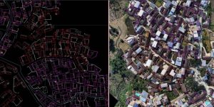
3. Solution: Jingwei M350 RTK + DJIH30T+ DJI Smart Map
Phantom 4 RTK + DJI Smart Map