Unmanned aerial vehicles can quickly conduct large-scale two-dimensional and three-dimensional models, reduce field costs, and automate data processing.
Shorten the operation cycle.
1. Business challenges
Topographic surveying requires a large amount of fieldwork and the cost remains high
The traditional collection method has low collection efficiency, long construction period and cannot be delivered in time
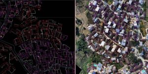
Traditional surveying and mapping results are limited to digital line maps and cannot visually display the topography and landforms
2. Advantages of drones
It is capable of conducting 1:500 image-free topographic surveying
The operation efficiency is approximately 5 to 10 times that of the traditional collection method
We can provide DOM, DSM, real-scene 3D models, digital line drawing diagrams and other achievements as needed
3. Recommend a combination of solutions
• Hydrogen Peng XC02/ Sailor 6100X / 6/X4D